Improving urban mobility… one scooter at a time
A data-driven approach to managing shared mobility
As shared transportation services expand across the globe, the shared mobility landscape has continued to grow — with more devices, more riders, and more trips every day. As Diego Canales reports, two American jurisdictions are using shared mobility data from e-scooters to make informed decisions on how to re-allocate public space and manage multiple private operators in the public right of way
Cities around the world have experienced the rapid introduction and expansion of new, shared mobility services – carsharing, bike-sharing and now scooter-sharing. The data generated by these new mobility services can help cities better monitor and manage new mobility pilots, but the volume of data can also be a challenge to analyse, particularly from a large number of operators.
Building on decades of experience developing software and analysis solutions for public agencies, Populus introduced its Mobility Manager platform early last year to help cities securely and effectively manage mobility data from multiple operators and multiple modes, including shared scooters, bikes, and cars. Their advanced analytics platform helps city transportation planners get the information they need by ingesting real-time and historical data from fleet operators. In these two case studies, we highlight our work with two American jurisdictions (Arlington County, Virginia and Chicago, Illinois) to help public agency staff assess data from mobility operators and evaluate their e-scooter pilot programs.
Populus Mobility Manager analyses millions of parking events to help cities identify and monitor parking for new modes
Managing e-Scooter Parking in Arlington County, Virginia
Arlington, Virginia, a county of over 200,000 residents across the river from Washington, DC, launched an e-scooter and e-bike pilot program in October 2018. Each operator was allowed a fleet size of 350 vehicles, with the opportunity to increase its fleet if utilisation was high (at least three trips per device per day over a full month).
After launching, the quick adoption rate of e-scooters in Arlington led to growing questions about how new mobility devices should operate in the public right-of-way: where were the best locations to pick up or drop off scooters, and where should scooters not be placed due to local business concerns or other factors? Each operator was required to park its scooters in a manner that did not impede pedestrian access or obstruct access to the public right of way, and County staff wanted to promote good parking behaviour.
To incentivise parking in areas that did not obstruct the public right of way and were also popular for riders, staff needed to understand patterns of scooter usage and make data-driven decisions on where to install on-street scooter
parking corrals.
Parking Data Analysis
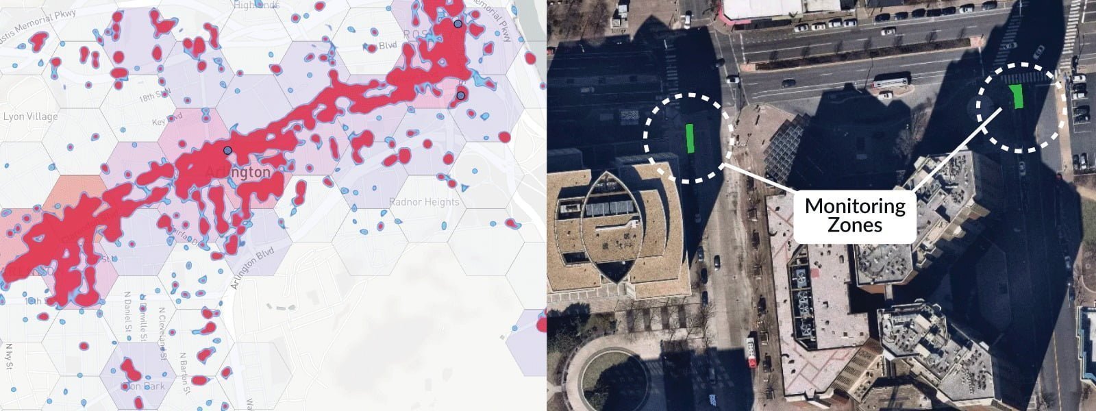
Utilising data from Mobility Data Specification (MDS) feeds, which provide information about vehicle status as well as trip data, staff analysed heatmaps of recent scooter parking events. Based on this heatmap analysis, they created geofenced areas as potential parking zones to monitor, as well as restricted parking areas around landmarks like the Pentagon. MDS data allowed staff to review both current and historical trip data and highlight which zones were most popular for scooter parking.
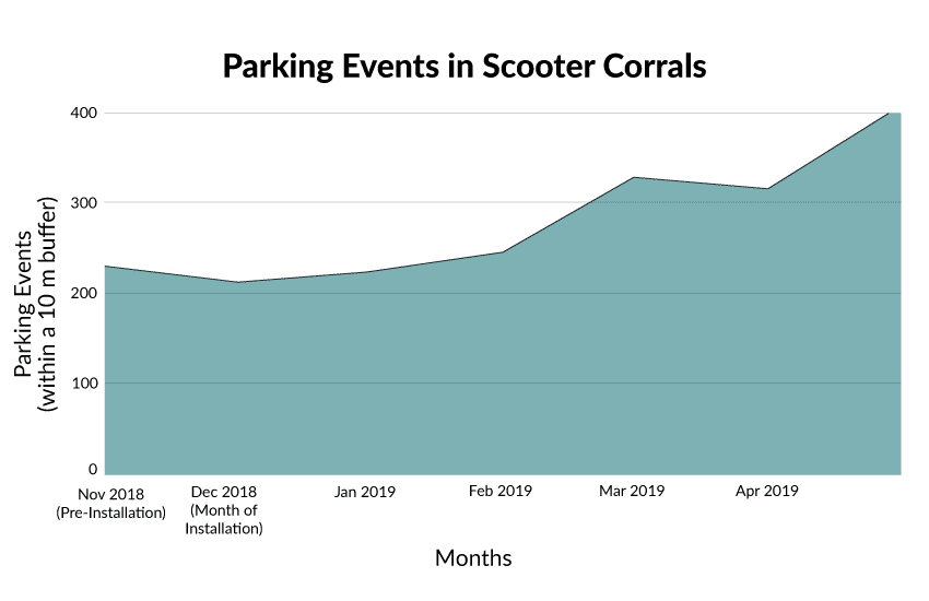
Parking Events in Arlington's Scooter Corrals
Parking Corral Installation
Based on the parking count information captured in the monitoring zones, staff determined priority sites for scooter parking corrals based on areas where riders were already parking large numbers of vehicles. In December 2018, staff identified on-street parking opportunities for seven new scooter corrals near six Metrorail stations. The city also worked with scooter operators to promote the corrals in their apps, so riders would know where to park their vehicles. In the months after installation, the corrals saw steadily increasing parking usage, demonstrating the density of usage nearby as well as the success of allocating space in the public right of way based on data.
After seeing over 300,000 trips on scooters during the pilot, the county voted unanimously to extend the program through the end of 2019, and installed additional corrals in June, July and September of 2019. In a recently released report, Arlington County evaluated their shared mobility device (SMD) pilot and found a firmly positive response from riders as well as increased deployment and utilisation of SMDs.
The quick adoption rate of e-scooters in Arlington led to growing questions about how new mobility devices should operate in the public right-of-way
Managing an e-Scooter Pilot with Multiple Operators in Chicago
The City of Chicago launched their e-scooter pilot program in June 2019 with 10 different companies and 2,500 total scooters in a pilot geographic area on the city’s west side. Chicago’s rules for scooter operators during the pilot included operating times (5am-10pm), geofenced operating areas, and GPS data sharing requirements. Using the Populus platform, the city has found a way to manage the program with more visibility, as well as to easily harness data for future transportation policy and planning.
Chicago’s ambitious approach to bringing in a large number of micromobility companies presented some interesting challenges, including the need to access complex data streams from multiple operators with different levels of data-sharing compliance. Populus worked closely with the city and each operator to ensure that all required data feeds were compliant, validated, and usable. City staff can now easily access data from all 10 operators in one dashboard, with views on available vehicles, deployments in prioritised equity zones, and trips taken in the pilot area.
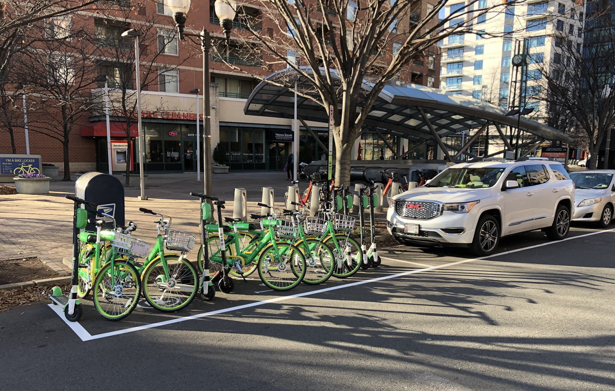
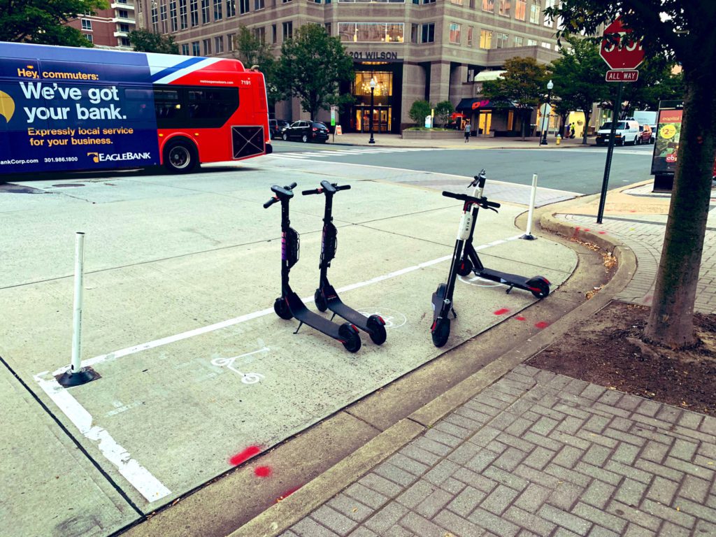
Scooter Corral in Arlington, VA
Real-Time Location Data
Chicago city staff can quickly see scooters inside or outside the pilot program area in real-time. Live location data via the General Bikeshare Feed Specification (GBFS) data feed helps field staff perform physical spot checks to find scooters outside the boundaries and notify operators who are out of compliance.
Chicago's ambitious approach to bringing inca large number of micromobility companies presented some interesting challenges, including the need to access complex data streams from multiple operators
Advancing Transportation Equity
To ensure residents have equitable access to scooters across the pilot area, Chicago requires operators to deploy 50 percent of its total fleet in two priority areas. Using the Equity map, staff can view vehicle availability in the priority zones over time and by operator. Staff can also track operator adherence to the city’s overall vehicle cap (250 maximum per operator). Historical data for the entire fleet is available, as well as data for each scooter operator.
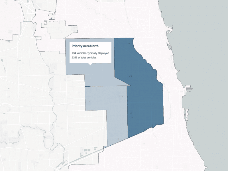
The Populus Equity Map helps staff measure vehicle distribution throughout the pilot area
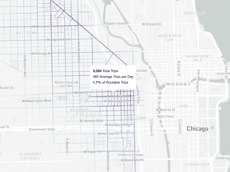
Visualisation of trip volumes in Chicago, IL
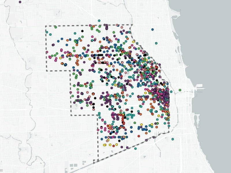
Populus live map visualises vehicles from all scooter companies
Visualising High-Volume Routes
Transportation infrastructure decisions can be complex and challenging. By visualizing data on where the highest number and volume of trips are taking place on their city streets, staff can use a data-driven approach when determining where to prioritise multimodal infrastructure like new bicycle lanes or crosswalks.
Without data, it’s impossible for cities to measure progress towards their transportation goals. By requiring access to data feeds from shared mobility services, public agencies can learn how, where and when people are moving through the city, and are better equipped to develop informed policies and transportation plans. Populus provides tools to help improve coordination and communication between shared mobility operators and cities, helping deliver safe, equitable and sustainable streets for the future of mobility.
FYI
Diego Canales is Global Partnerships Manager at Populus
diego@populus.ai