Guiding the (Traffic) Flow
Navigation systems are evolving to prioritise societal impact over speed, reducing through traffic on local roads. Backed by European standards, the digital Traffic Circulation Plan (TCP) empowers cities like Ghent, Gothenburg, and Amsterdam to guide smarter routing. The goal: a unified system that improves road safety, sustainability, and urban quality of life across Europe.
Navigation systems play a significant role in enhancing road safety. They help drivers stay focused by reducing the need to search for directions and by providing personalised, language-specific guidance. Whereas drivers once relied on paper maps spread across the steering wheel, they now benefit from a wealth of relevant, real-time travel information, knows as Real-Time Traffic Information services (RTTI). The corresponding EU Delegated Regulation, part of the ITS Directive, outlines how this data should be made available and encourages public-private partnerships to improve data quality.
As a result, the information is becoming increasingly accurate and complete, with more people using navigation systems—even for familiar, everyday routes.
However, the routes suggested by navigation service providers do not always align with the goals of policymakers. This misalignment partly stems from the fact that providers have historically used their own functional road classifications.
What can road authorities do to influence the routes proposed by service providers?

A TCP is a RTTI data type (2b) including Functional Road class and could contain some specific use cases, CROW
The EU RTTI Regulation has enabled the sharing of data for road functionality through what is known as a Traffic Circulation Plan (TCP). Until 2022, however, service providers were not required to incorporate this data into their services. With this obligation now in place, road authorities are now called to provide it in a standardised way.
But to do so effectively, it is crucial that we first clearly understand what a TCP is—and what it is not. To this end, POLIS and CROW, in collaboration with other European local road authorities, have developed a shared definition:
‘A Traffic Circulation Plan (TCP) is a set of permanent traffic management measures designed by traffic managers to control and guide traffic flows in response to permanent or recurring traffic disturbances. This plan must guide traffic flows based on policy objectives, provide a framework for optimising the transportation network, and align with existing regulations and infrastructure. Additionally, it should be communicated in a standardised language, define the functionality of roads based on a Functional Road Classification, and support navigation services in promoting sustainable and efficient routes.’
Essentially, a TCP outlines the policy-defined function of roads to manage traffic. These functions should be structured according to a European standard to ensure that they are usable by service providers.
While local authorities may apply their own functional terminology, the digital release of this data for reuse is most effective when aligned with a widely accepted European model—such as the Functional Road Classification proposed by INSPIRE.
The link with navigation
Navigation services aim to quickly direct users to roads with the highest available function and then guide them to their destination. Factors such as road function, distance, and real-time congestion influence this routing. Navigation tools serve individual users, while policy focuses on collective benefit and aims to guide traffic in societally desirable ways. Recognising these differing goals enables a productive dialogue between both perspectives.
Yes—service providers are now required under the RTTI Regulation to include road functions set by public authorities in their services. However, this must be implemented fairly and reasonably. If policy-based routing leads to excessive detours, users may ignore navigation instructions altogether.
Digitalising a TCP: a step-by-step approach
To support effective implementation, POLIS and CROW have developed a step-by-step guide. The first step is to input road classifications as defined by the RTTI Regulation—which solely focuses on physical infrastructure, such as road dimensions and the number of lanes.
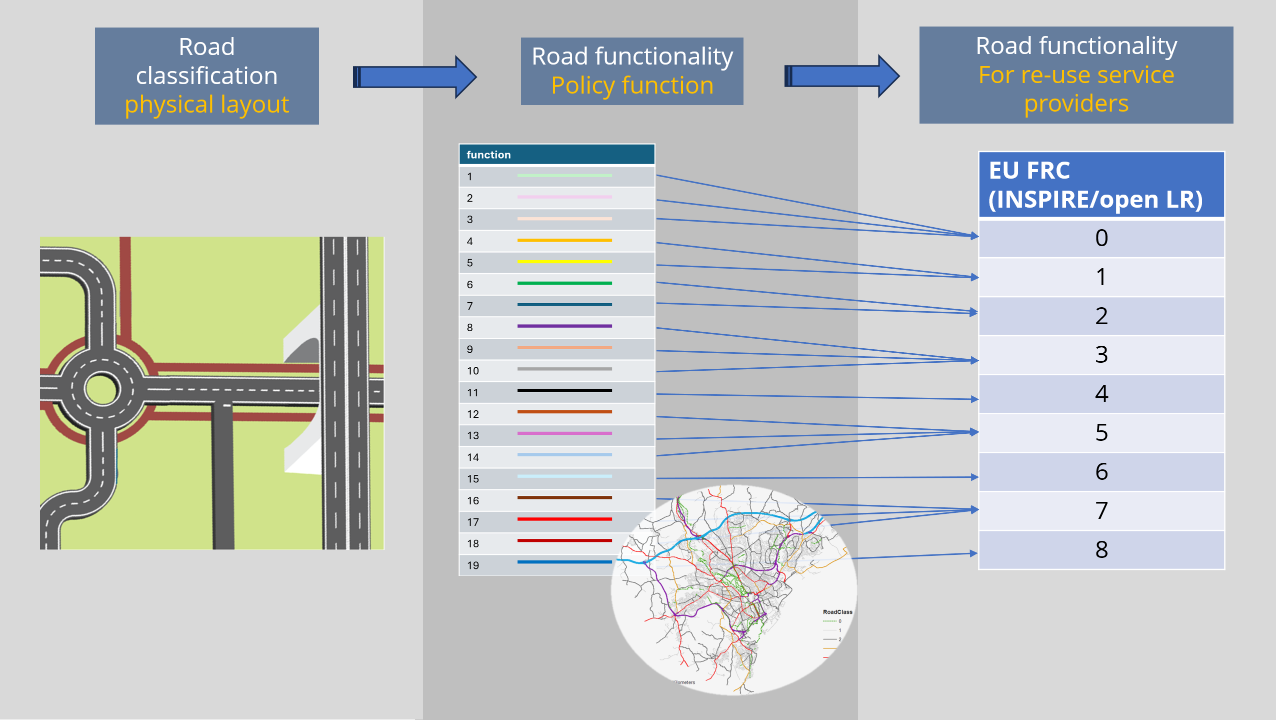
Road classification, CROW
These physical characteristics naturally influence a road’s function; for example, a narrow street cannot realistically serve a high-capacity function. As such, these data elements are closely interrelated. Similarly, traffic rules—like one-way designations—are also linked, although they are managed in separate data fields within the RTTI framework.
Next is assigning road functions based on policy, which may be defined at national, regional, or local levels, and ideally in consultation with neighbouring authorities to avoid inconsistencies at jurisdictional boundaries. Where road function alone does not achieve the desired outcome, additional local use cases may be applied.
These include avoiding roads near schools during peak hours, discouraging through-traffic on collector roads, or maintaining flow on major routes during congestion. More use cases are likely to emerge over time.
A TCP does not include traffic signs or temporary restrictions—these are already covered under other RTTI provisions. Likewise, roadworks and closures are separately managed and made available to service providers when provided by the authority.
Laying the groundwork
When can a TCP truly make a difference? It offers road authorities with a tool to influence routing—especially when issues arise. If navigation is functioning as desired, no action may be needed. But where problems occour—such as at specific locations or due to inconsistencies between service providers—publishing road functions can offer a solution.
Next steps
With a clear direction set by European road authorities, the time is ripe for engaging service providers in constructive dialogue. Efforts are underway to define a European standard for sharing Functional Road Classifications. A proposal is currently being developed to launch public-private pilots that assess the impact of integrating policy data into route planning.
Road authorities will not be rewriting algorithms, but will define parameters for road usage—ensuring that navigation services align with contemporary mobility goals.
Click here to read the article in its original format.
About the author:
Gerard van Dijck, Program Manager Smart Mobility, CROW Institute. Van Dijck brings over 24 years of experience in traffic and transport. He currently serves as program manager for Smart Mobility at the Dutch knowledge institute CROW. His expertise includes traffic management, smart mobility, traffic control systems, human factors, and regulatory frameworks. He plays a key role in bridging strategic policy, technology, and practice, driving innovation and collaboration across sectors.
 Shutterstock