Every Step Counts
Discover how user satisfaction is reshaping pedestrian indicators in Europe. The Walkability.App, a user-friendly tool gathering data to enhance urban walkability, shows how user-driven insights are transforming city planning and sustainable mobility.
To listen to the recording of the article below, please accept all cookies.
Several years ago, the European Commission was seeking to establish a single indicator for measuring walking. At the time, ‘Km of bike lane’ served as the sole indicator for cycling, with an underlying assumption that ‘Km of footpath’ would serve as a fitting counterpart. However, critical questions arose regarding the connectivity and continuity of these lanes and paths, their utilisation by the public, and the quality of these pedestrian infrastructures. It became evident that these intricacies held significant importance.
Practical, affordable, and measurable indicators for walking have been in development ever since, spearheaded by the International Measuring Walking Group, which is coordinated by Daniel Sauter.
Sauter is also part of the team helping develop a pan-European Masterplan for Walking, set to be published by UNECE and WHO in 2024. During the team’s recent meeting in Portugal, a fresh set of indicators was adopted. The new system encompasses measurements related to activity, safety, accessibility, comfort, and user satisfaction. Notably, in discussions with national governments, consensus was reached that if there were a single indicator for walking, it should prioritise user satisfaction.
The Walkability.App
Satisfaction is crucial as many walking environments are not necessarily safe, accessible, or comfortable, and it is the combination of these deficiencies that fundamentally encourages people to motorise (where there is an affordable alternative). To both keep people on their feet and encourage more people to walk more often and further, it is imperative to invest in positive pedestrian experiences. This investment will yield significant benefits in terms of improved mental and physical health, enhanced economic vitality and greater environmental sustainability.
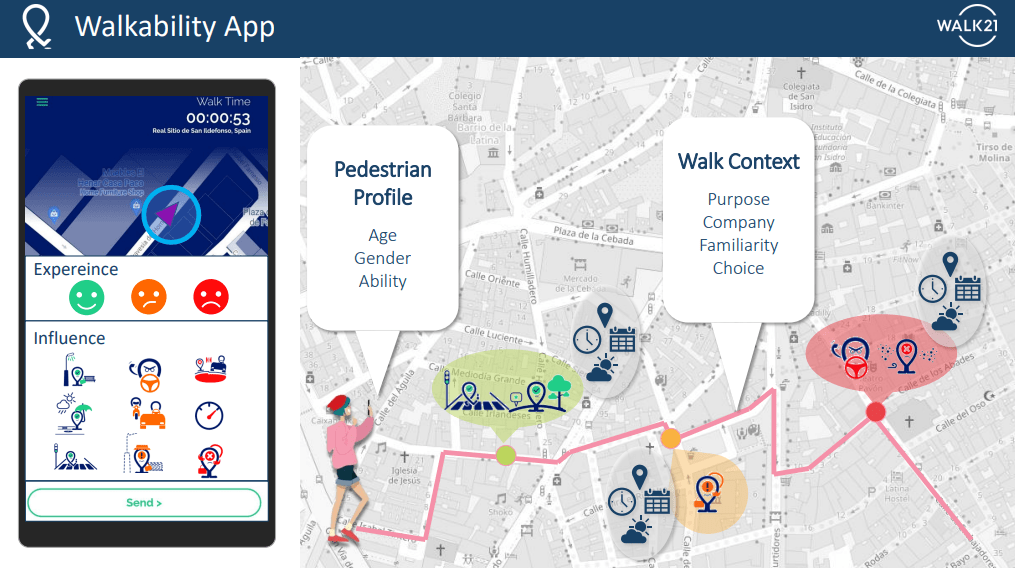
The Walkability.App. Credit: Walk21 Foundation
To measure pedestrian satisfaction, the Walk21 Foundation has collaborated with researchers worldwide since 2017 to explore various approaches and tools. Seed funding from GIZ led to the development of a prototype, which was deployed in Lagos, Nigeria, and resulted in a new footpath and crossing being built based on the feedback of 2,000 local people. Further trials in Medellin and Dhaka also harnessed citizen-generated data to inspire government initiatives, which resulted in both a reduction in pedestrian fatalities and increased public contentment. The culmination of these efforts is the Walkability.App, a tool developed in partnership with academic experts from CEDEUS, supported by Alstom, and now available for download on Google and Apple stores.
The Walkability.App is a user-friendly mapping tool designed for pedestrians, allowing them to assess the walkability of their experiences in public spaces. This app is available for free, and while communities have the option to utilise it independently to bring attention to their concerns and trigger a response, it is currently primarily employed within project initiatives led by reserachers, NGOs, or city authorities.
A concise instructional video detailing the usage of the Walkability.App is available on YouTube. In practical terms, the app gathers data related to pedestrian characteristics, such as age, gender, and physical ability, as well as information about the walking context, like trip purpose, group size, and familiarity with the environment. It also records the perceived walkability of experiences, categorised as positive, with some concerns, or negative, and the environmental determinants influencing the experience, which are predefined into 12 categories. Additionally, the data is automatically geocoded, timestamped with the date and time of the report, and notes the prevailing weather conditions at that moment.
Revolutionising data collection
Data collected through the app is securely stored on a dedicated server and can be accessed via the Walkability.App web platform. The platform visualises this data geographically, and users can employ filters to explore any combination of variables. This allows for in-depth exploration, such as examining how different demographics, including women, people with disabilities, or the elderly, perceive public spaces. Users can also pinpoint areas where perceptions are positive and identify specific concerns related to factors like traffic speed, path quality, and safety.
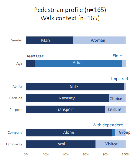
Walkability.App data - Alf Maskan, Cairo. Credit: Walk21 Foundation
The Walkability App has recently been applied in two distinct case studies, namely Dublin and Cairo. In Dublin, a report from Transport Infrastructure Ireland highlighted a gender disparity, where women were less likely to use the tram and more inclined to opt for driving compared to men. The app was instrumental in collecting over 800 experiences from women within tram catchment areas to identify what interventions could be made to support more sustainable transport choices. Notably, concerns centred around issues like extended wait times at traffic signals and insufficient crossing times, along with footpath quality.
In a similar vein, the study conducted in partnership with Transport for Cairo employed the app to evaluate the quality of public transport catchment areas. The findings indicated that time of day and gender played a significant role in shaping perceptions of walkability within the city. Additionally, the study highlighted differences in the design and management of station catchments between the historical downtown of Cairo and the newer developments on the outskirts of the city, which ultimately affected modal choices, offering valuable guidance for policymakers.
Carlos Canas, the Walkability expert at Walk21 and lead of the app, said: ‘We can aggregate observations and calculate areas that are considered more pedestrian friendly as they are linked to positive experiences, and areas considered less pedestrian friendly due to some concerns and negative experiences. This helps identify and prioritise areas that require more attention and, crucially, to know what specific interventions are needed to improve their walkability.’
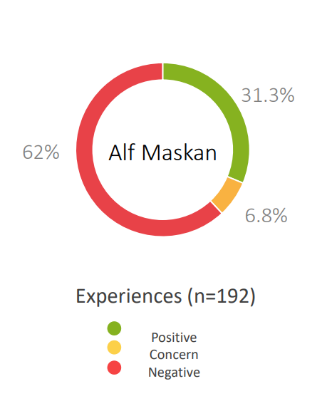
Walkability.App data - Alf Maskan, Cairo. Credit: Walk21 Foundation
The Walkability.App is a valuable tool for cost-effective and straightforward data collection, enabling a better understanding of walkability in any given street, area, or neighbourhood. Significantly, it does not merely reflect the perspective of a single traffic planner or engineer, but, instead, encapsulates the collective experiences of the community.
And, of course, the Walkability App can also be used as a highly effective evaluation tool. A case in point is Lund, Sweden, for example, where it was recently employed to assess the before and after impact of temporary street interventions put in place for European Mobility Week. This approach enables a comprehensive understanding of how the perceived walkability of an area evolves following an intervention and identifies the groups that benefit the most from it. It facilitates both quantitative and qualitative measurements, allowing for a more robust assessment of the true impact of a project. In Lund, the expectation is that this evaluation will not only inform the development of a new walking policy, but also trigger permanent street transformations designed to enhance the pedestrian experience throughout the city.
‘There are dozens of factors that impact every walking experience and several systems are offering to audit and assess up to 200 variables, but at some point,’ says Jim Walker, Founder of Walk21, ‘we need to be pragmatic, and allow citizens to share what matters where. Using the Walkabilty.App helps make the needs of all pedestrians more visible and makes it easier for governments to respond efficiently with targeted interventions that are more likely to be effective.’
Click here to read the article in its original format.
About the authors:
Jim Walker is the Director of the Walk21 Foundation. He founded Walk21 in 2000 and has, for more than 20 years, championed a global network to develop research, projects and policies so that people can walk in safe, attractive and accessible environments. He is currently helping develop an Active Mobility plan for Africa and a Walking Masterplan for the pan-European region.
Carlos Cañas is a Technical Expert at the Walk21 Foundation. Trained as a geographer, he researched walkability as a doctoral student at the Institute for Climate Change and Sustainable Development, University of Malta. At Walk21, he provides technical expertise on a variety of projects, including the Walkability App. Carlos also founded Walking Malta, a community research project that applies Citizen Science principles to walkability research and policy.