What is up in USEPE?
Lately, the USEPE partners have been finalising preparations for the flight simulation over virtual Hannover. In the framework of these preparations, we suggested an updated airspace height for the simulation, to maintain better safety and capacity for drone flights.
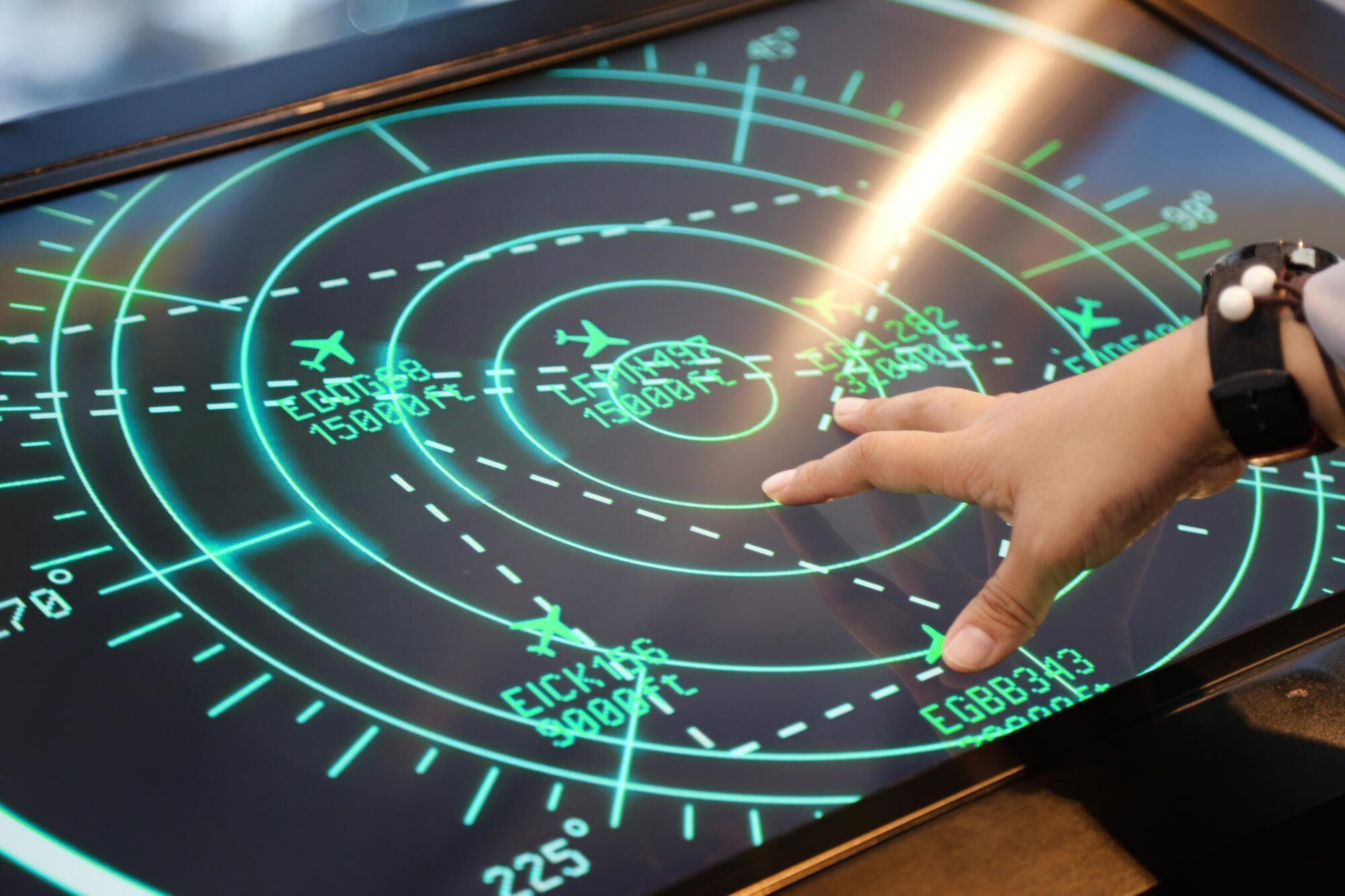
This article aims to outline challenges related to the organisation of drone operations in urban areas. This communication is for a non-expert audience. For more technical information, please visit our website usepe.eu.
To validate our simulations, we defined some assumptions. For instance, we suggest extending the U-space airspace above the Very Low Level (VLL) limit to 1000 ft (ca. 300 meters) instead of 500 ft where it is necessary, for example over cities with tall buildings. In other locations, such as over airports, a lower limit can be used, because in these areas every participant is flying under air traffic control. Thus our D2-C2 airspace structures do not apply at all.
Background:
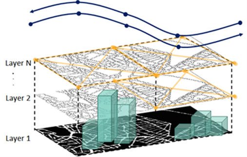
The D2-C2 airspace organization includes three types of airspace:
- Segments, routes in between buildings (from layer 1 to 2 in the illustration)
- Segments, routes over buildings (from layer 2 to N in the illustration)
- High-speed corridors (over layer N in the illustration)
 Considering that the tallest buildings in Hannover reach 100 meters above ground level, an upper limit of 500 ft / 150 meters leaves very little room for routes and corridors above the buildings. This led to the decision that within the USEPE project, an update of the upper limits for drone operations is needed. Thus, we suggest extending the airspace used by drones up to 1000 ft / 300 meters. The airspace would be organized as follows:
- From 25 meters to 100 meters: Segments, routes in between buildings
- From 125 meters to 225 meters: Segments, routes over buildings
- From 250 to 275 meters: Corridors:
- At 250 meters: Corridor 1
- At 275 meters: Corridor 2
- From 275 to 300 meters: Buffer zone against other traffic
A 25 m buffer zone against the general airspace above the city is planned for higher safety of operations. The illustration matching the current simulation setting can be updated like this:
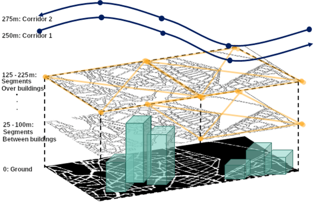
Figure 2
It is important to highlight that it would be possible to put the corridors lower, in between segments, but that is not possible at this stage with our simulator. This will be addressed in the revised concept of operations and validation report.
To confirm the simulation height update we reviewed the actual airspace situation above Hannover. (See figure 3.)
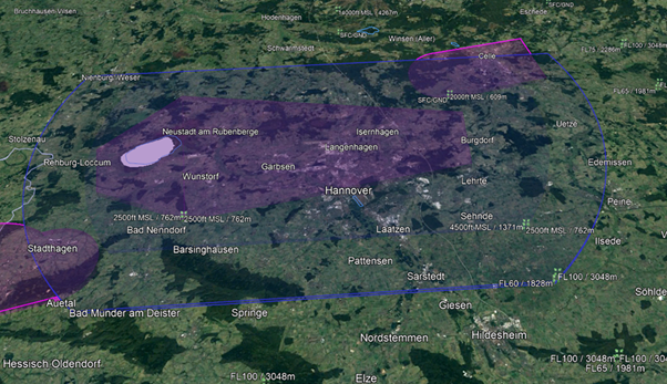
Figure 3
There are different kinds of height and altitude references: Altitude above mean sea level (MSL) and height above ground level (AGL).
MSL is used for higher altitudes, for example, for airliners. At their altitudes even a moderate mountain becomes insignificant. Therefore, they can safely ignore the actual “stuff on the ground” and refer to all heights to the level of the ocean. The numbers for the altitudes then quickly become really big. Therefore, we usually abbreviate the larger altitudes as so-called “flight levels” (FL). One flight level is 100 ft. FL60, for example, is just a short form for 6000 ft MSL.
AGL is used whenever you get closer to the ground. Suddenly mountains, hills, even buildings, and trees can become important or dangerous for an aircraft or drone. Thus, altitude is referred to as ground. This is the main reference frame for smaller drones operating at lower altitudes. For more explanation of altitudes and flight levels, see https://skybrary.aero/articles/altitude-flight-level-and-height.
The purple area in figure 3 is the actual control zone of the airport. It starts at 0 (ground level) and extends up to 2500 ft MSL.
The blue areas (two of them) are the two layers of airspace D around the airport. Airspace D is the airspace where air traffic control is taking care of everything and normally a drone would not be allowed to enter there except for a special purpose like runway inspection. Both airspace D layers extend above the entire city with the larger one starting at FL60 and the smaller one starting at 2500 ft MSL.
There are two more airspaces: One is airspace E, which is also called controlled airspace, just like D. There are several differences between both, but that is not relevant to this discussion, as these airspaces are not affected by U-space. The other one is airspace G. G is called uncontrolled airspace since air traffic control does not control the traffic therein. Most of the lower airspace in Germany (and worldwide) belongs to airspace G, and so does the air above Hannover.
According to EU regulations, all flights above cities must be higher than 1000ft / 300m above the highest building (in a radius of 2000 ft). This is in line with our updated height proposal. We created an illustration with all the parameters represented to explain the flight altitude change:
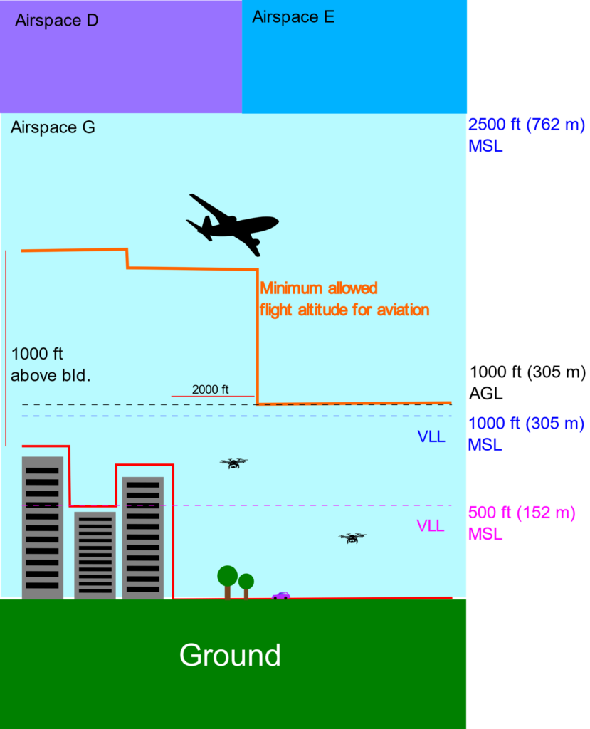
Figure 4: Revised airspace organisation
The USEPE team will use the updated altitudes as in the illustration above for the drone simulation flight. This will be reflected in the upcoming update of our concept of operations, and the validation plan of our separation method. We hope this short explanation gives a glimpse of our activity and teases stakeholders to wait for our final deliverables…!
More information
For more information on USEPE and upcoming events visit the project website.
In case of any questions, suggestions, etc. contact Dzvenyslava Tyslyukevych and Manon Coyne.
- Related Events
- Related Projects
- Related Pictures
USEPE Final ConOps Workshop: U-space for the future Air Mobility – concepts and challenges