Laser focused on a cleaner tomorrow
“No problem can be solved from the same level of consciousness that created it.”
Albert Einstein could have been referring to transport’s contribution to rising air pollution levels, as Yolla Hager and Allison Kelly discuss
Cities around the world today are facing a real crisis due to air pollution and climate change. Carbon dioxide, the main contributor to climate change, which is produced through the burning of fossil fuels, makes transportation a major source of air pollution in cities around the world. In Europe alone, 800,000 people die annually due to air pollution.1
According to the European Parliament website, “transport is responsible for nearly 30 per cent of the EU’s total CO2 emissions, of which 72 per cent comes from road transportation.”2 Studies have shown that if policies stay the same air quality goals will not be met.3 Many cities in Europe today face fines due to air quality breaches above Euro standards. Cities must intensify their efforts to find an immediate solution that is effective and can provide instantaneous results. As with any issue that needs to be solved, the matter must be studied and based on facts, not predictions! The only effective way to solve this predicament is to continuously monitor and regulate vehicles on the road in real time.
How can European cities deliver on air quality promises?
Diesel related pollution from vehicles is an invisible killer that needs to be addressed with realistic facts to find an effective solution. The focus should be on more accurate on road, real world emissions measurements; such as, Market Surveillance and In-service Conformity checks as recommended by the European Commission rather than laboratory type approvals and Euro Standards.
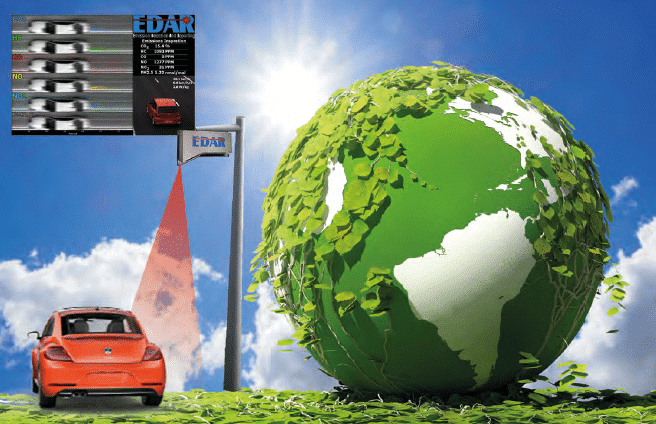
Remote sensing technologies like EDAR have the capability of providing a cost-effective, large sample size of vehicle emissions records for fleet screening applications in real time. As referenced in a recent ICCT report, “this data would provide valuable emissions information to authorities and would help in the identification of vehicle models with poor or suspicious real-world performance. This could then direct the more rigorous, and costly, measurement methods such as PEMS and chassis dynamometer testing as part of market surveillance programs. Similarly, the short- and long-term effectiveness of, for example, promised emission improvements can be tracked over time. In addition, remote sensing can be used to identify high-emitting vehicles, detect individual tampering, and encourage proper maintenance of vehicle emission control systems.”4
Remote sensing technologies, such as EDAR, can also provide important information such as NOx measurements, which is not available at this time in smog stations throughout Europe due to capabilities being fairly limited and cost prohibitive. In an attempt to mitigate vehicle related pollution, cities are implementing Low Emission Zones (LEZ) and Clean Air Zones (CAZ) that have been found to be ineffective.
 Where are current air quality proposals falling short?
Establishing regulations for air quality based on laboratory settings without real world data confirmation is the main reason that air quality proposals fall short.
A recent El Pais article quoted Nuria Blázquez, the transportation coordinator of the environmental group Ecologists in Action, stating, “the main problem is that there is no clear ‘legal definition’ of what is a low-emissions zone. The term could be applied to areas with strict restrictions or those with very little effectiveness.
That is the case, for example, in German cities, where there are only restrictions against the oldest vehicles, and there has been no change [in pollution levels].”5 Recent air quality initiatives, such as low emission zones, are based on Euro emissions standards and as on road remote sensing studies have shown Euro emission standards are extremely unreliable.
Many cities face fines due to air quality breaches above Euro standards. Cities must intensify their efforts to find an immediate solution that is effective and can provide instantaneous results
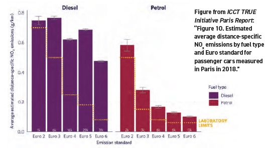
For example, the TRUE Initiative Paris Report shows using data from EDAR that “on average, NOx emissions from Euro 6 diesel cars in Paris are elevated relative to most petrol cars measured in the study. The mean distance-specific NOx emissions of Euro 6 diesel cars are 4.8 times the emissions of Euro 6 petrol cars, and only 18 per cent lower than the emissions of the oldest (Euro 2) petrol cars.”6
Are Low Emission and Clean Air Zones an effective solution?
At this time LEZs and CAZs limit the number of vehicles entering according to Euro Class allowing only newer vehicles into the LEZ, which is a highly discriminatory system based on the ability to buy a new car. As studies have shown from real world emissions testing not all cars, whether diesel or petrol, emit equally. Restricting vehicles according to Euro standards has been proven in real world studies to be ineffective and unfair due to the fact that well maintained vehicles of most euro classes can be as clean as newer vehicles. In the past, the only technological choices available to cities for monitoring their fleet were license plate recognition cameras.
Establishing regulations for air quality based on laboratory settings without real world data confirmation is the main reason that air quality proposals fall short
 Establishing regulations for air quality based on laboratory settings without real world data confirmation is the main reason that air quality proposals fall short
Today, cities have the option to use remote sensing technologies that offer a means to cost effectively, screen large amount of vehicle in a short amount of time, while identifying clean or dirty vehicles on the roads in real time. With this type of information, governments can enforce LEZs and CAZs according to the emissions vehicles are actually emitting. Using remote sensing to continuously monitor will allow governments to perform In-service Conformity Checks and Market Surveillance by enforcing the following measures:
- Governments can set “cut points” that will help identify the cleanest and dirtiest vehicles in their fleet by monitoring vehicles driving habits over time.
- After the clean vehicles have been identified on road a number of times, a list can be published on a government website allowing these vehicles to enter the LEZ regardless of euro class without penalty therefore rewarding the cleanest vehicles on road; which will incentivise positive behavioural change among motorist.
- Identify high polluters on the road and direct them to a car test station for further evaluation.
- Anti-tampering campaign that identifies vehicles or trucks with malfunctioning or disabled diesel particulate filter (DPF) and selective catalytic reduction (SCR) systems or depleted AdBlue.
- True assessment of complementary emissions reduction programs, such as retrofits or scrappage, can be evaluated effectively overtime therefore identifying the degradation of the retrofit components in real time.
- Help cities to forecast their next air pollution warning during hot days.
In summary, governments that apply these measures using real world data through the use of remote sensing will be able to implement valid and fair Clean Air Zones while promoting positive behaviour among motorists.
Governments that apply measures using real world data through the use of remote sensing will be able to implement valid and fair Clean Air Zones while promoting positive behaviour among motorists
How can remote sensing data help cities with air pollution?
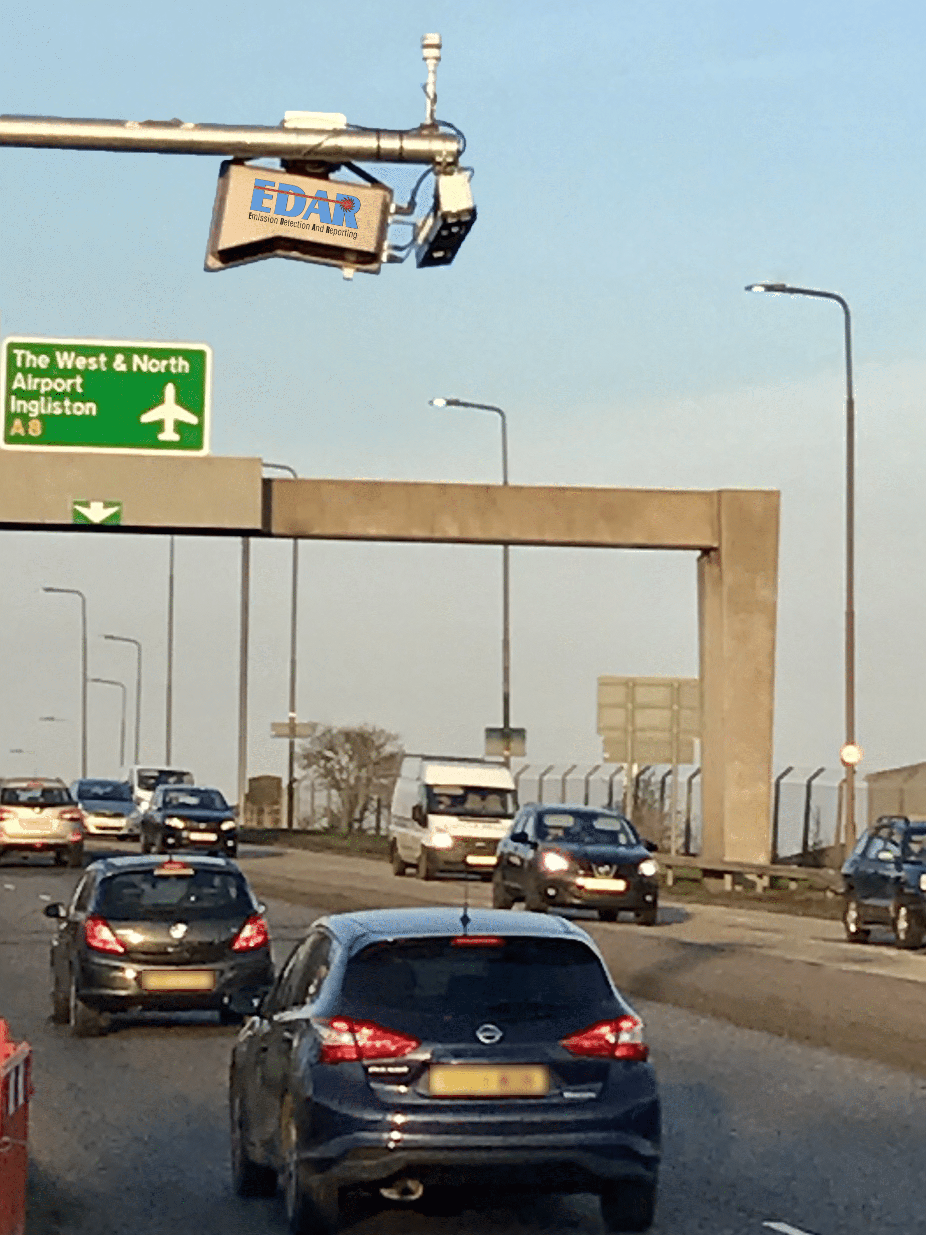
EDAR on a multi-lane road in Scotland
Remote sensing can provide a statistically significant, cost effective data set that will ultimately assist with future policies and regulations, as well as emission and mitigation strategies. According to Yoann Bernard of ICCT, “cities that urgently need to tackle air pollution from [the] transport sector, need to base their policies on real-world emission evidence for maximum effectiveness. Remote-sensing technique allows cities to well understand emissions from their fleet and identify the largest culprits that can vary for each studied city (e.g. special taxis fleets, fleet age, share of diesel/petrol engines, etc)”.
Bernard continues to explain the findings of the recent Paris report, published on 10 September 2019, by stating “the EDAR system allowed the city of Paris to perform measurements efficiently on a continuous 24-hour period. The collected data permitted ICCT and City of Paris to identify a worrying pattern in NOx emissions from Euro 6 diesel cars showing an average increase of 30 percent when temperature rises above 30 degrees Celsius. That kind of evidence can be very helpful for cities to forecast their next air pollution warning during hot days and decide which vehicles they should restrict access to the city.”
- 24 hour unmanned monitoring
- Real world detection of gases such as: CO, CO2, NO, NO2, (NOx), HC, PM
- Detecting the temperature of the exhaust
- Detection on multi-lane roadways
- Detection on high speed motorways
- High number of valid records in a short time period
- Operation in all weather conditions except heavy rain or snow
- Detection of any vehicle type with a single unit
- Detection of the shape and size of the vehicle
- Detection from above and goes virtually unnoticed by motorists
Furthermore, Christophe Najdovski, the city of Paris’ deputy mayor stated, “the use of remote-sensing devices to measure urban emissions from vehicles is an easy and efficient way to get a clear picture on real emissions. During the few weeks where the EDAR system was installed in Paris, we collected more than 180,000 data [records] that provided important insights about diesel car emissions and, for the first time, two wheelers. It allows us to go further in interpreting the trends of the air quality we breathe.”
 While Euro standards are based on the vehicles’ performance in laboratory tests, EDAR is capable of directly analysing the whole exhaust plume of a vehicle while it is on the road, differentiating between polluting and clean vehicles immediately allowing cities to target policies far more accurately and effectively.
The technology exists that will aid cities around the world in meeting their air quality goals quicker, easier, and more effectively. By implementing the use of a cost effective, remote sensing system like EDAR to continuously monitor, cities will be able to achieve instantaneous, and positive results in real time.
References
- https://eurekalert.org/pub_releases/2019-03/esoc-apc030819.php
- http://www.europarl.europa.eu/news/en/headlines/society/20190313STO31218/co2-emissions-from-cars-facts-and-figures-infographics
- https://www.sciencedirect.com/science/article/pii/S0959378018304035
- https://theicct.org/publications/vehicle-emission-remote-sensing
- https://elpais.com/elpais/2019/09/11/inenglish/1568214176_656688.html
- https://theicct.org/sites/default/files/publications/TRUE_ParisRS_study_20190909.pdf
Yolla Hager is President and Allison Kelly Director of Communications at Hager Environmental & Atmospheric Technologies (HEAT)
www.heatremotesensing.com
yolla@heatrsd.com
allison@heatrsd.com