MobiDataLab Opinion Article: What’s the case for public authorities to buy transport data?
MobiDataLab is an EU-funded project supporting and promoting mobility data sharing. The project collects opinion articles from experts on the topic to showcase the potential of mobility data sharing and highlight challenges to overcome.
Suzanne Hoadley from POLIS Network is an expert on the data management challenges in local authorities’ mobility departments. For MobiDataLab, she discusses the different use cases and potential ways forward to improve the exploitation of mobility data as a basis for better policy and decision-making.
What you may find in the article
The growth in the quantity and quality of transport data available is opening up new opportunities for public authorities to improve transport planning and operations through data-driven analysis and decision-making. Seizing the opportunity to monetise their data offerings, data providers, including vehicle manufacturers, fleet managers, telecom companies and data aggregators, are busy building their data product portfolio and some are even engaging directly with city authorities to demonstrate the added value of their data.
Buying data does not come cheaply, be that for a one-off purchase of data sets (eg, historical data sets for traffic analysis purposes) or longer-term, real-time data delivery service (eg, real-time traffic flow data). Nor is it necessarily inexpensive for a public authority to generate its data, through systems such as embedded loops, traffic cameras or manual counts of transport modes. This is presenting public authorities with a dilemma: should they continue to invest in their own data-gathering tools and methods, or would it be wiser to buy data from third parties?
There is no clear answer, it depends very much on the purpose, quality and cost of that data. Where third-party data is a substitute for data that is or can already be provisioned through established tools and methods, an assessment of the pros and cons of both channels should be undertaken.
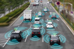
An interesting case is vehicle sensing and traffic flow monitoring which many road authorities perform for determining signal timings, calculating average travel times and generally supporting traffic operations. The most commonly used method for counting vehicles on an approach to a traffic signal is the embedded loop. Automatic number plate recognition (ANPR) cameras offer a traffic flow monitoring system, and they are typically deployed along key corridors to measure average travel times. Both these systems require on-street installations, resulting in limited and targeted installations (on the approach to key junctions and along key corridors). Providers of floating vehicle data (FVD), coming from in-vehicle sensors or aftermarket devices, claim that FVD can fulfil these functions and more. While this may turn out to be true, I have not seen any form of comparative analysis – if it does exist, please send it my way!
I have never come across any assessment of conventional and emerging data-gathering methods and tools, nor of the merits and disbenefits of the wider shift towards Data as a Service (DaaS) in the transport domain. Several city authorities have already admitted that they find themselves at a crossroads and do not know which direction to take. An impartial assessment could assist the public sector in making informed decisions about data acquisition, which would ultimately strengthen the wider data-sharing ecosystem.

Coming back to the case of vehicle detection and traffic flow data, there is a need to determine the strengths and weaknesses of the conventional systems widely used today (loops, Bluetooth, ANPR, etc) and of new data sources (FVD).
- Taking loops, for instance, a key benefit is a reliability – they detect every vehicle running over it; their main drawbacks include traffic disruption during installation, inadvertent cutting during road works, and their selective installation.
- As for ANPR cameras, a key benefit is their multi-functionality – they are used to enforce vehicle access regulations too, among other functions. The main disadvantages include their limited geographic deployment for obvious cost reasons, and in countries such as Germany where there is a cultural aversion to systems perceived as public surveillance.
- FVD’s main strength is its extensive geographic coverage – data can be generated on potentially any road. The main weakness relates to data availability and quality, in particular discrepancies between what is promised and what is delivered on the ground.

In addition to the above, there are a host of more generic, use case-independent issues to consider, which are not insurmountable, but they need airing and solving.
- Data usage and reuse conditions may be stricter for third-party data and may also be incompatible with the open data policies of public authorities;
- Data privacy challenges appear to be that much greater for GNSS data, which may be further accentuated when data is transferred from one party to another;
- Skills and know-how needed to specify the data tender, particularly the technical requirements and the contract clauses;
- Market issues, like healthy competition and pricing mechanisms.

Pricing is a determining factor. The slow growth of third-party data procurement by public authorities is in large part due to pricing, which several public authorities have complained to be too high. The introduction of the notion of FRAND conditions in the EU real-time traffic information delegated regulation is opening up a unique opportunity to develop fair commercial conditions for access to certain in-vehicle data sets by public authorities for the tasks of traffic and asset management and road safety. Preliminary discussions with POLIS members suggest that what constitutes a fair price is determined by the use case. These discussions will be pursued within POLIS over the coming years.
Follow @MobiDataLab on Twitter and Linkedin for more mobility data content!
- Related Events
- Related Projects